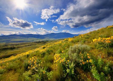
Spanning over 10 million acres, the shrubsteppe landscape is vital for a variety of wildlife and plant species, including some endemic to the region such as Columbia Basin pygmy rabbits. It is a critical area for habitat protection and conservation for species of greatest conservation need amid increasing threats from invasive species, wildfires, land use conversion, and other impacts. The Washington Shrubsteppe Restoration and Resiliency Initiative (WSRRI) seeks to address wildlife habitat protection and restoration challenges while also supporting working lands and communities in the face of wildland fire. Wildland fire preparedness, response, and recovery are important components of this effort.
The initiative is a targeted response to the Labor Day wildfires in 2020 and unique ecological challenges faced by shrubsteppe habitats, wildlife, and human communities within the Columbia Plateau.
Initiated in 2021 with a $2.35 million biennial allocation from the Washington State Legislature, WSRRI is a collaborative, focused effort to conserve and restore wildlife habitats, enhance wildfire preparedness and response, and support working lands in Eastern Washington's shrubsteppe landscape. This funding, part of a legislative proviso, is directed to the Washington Department of Fish and Wildlife (WDFW) and supplemented by an additional $1.5 million for the replacement of fences with wildlife-friendly alternatives.
About the Washington Shrubsteppe Restoration and Resiliency Initiative (WSRRI)
Helping wildlife also helps people
The primary purpose of the WSRRI is to benefit Washington's shrubsteppe wildlife, particularly in the face of increasing frequency and intensity of wildland fire, recognizing and acknowledging the shared benefit to human communities.
Working together to build a more resilient shrubsteppe
The WSRRI is making policy recommendations, identifying spatial priorities, and setting strategic direction to create a shrubsteppe landscape more resilient to fire, to better respond to wildland fire when it occurs, and to restore habitat after fires. As a collaborative initiative, the WSRRI is led by a tri-state agency steering committee consisting of the Washington Department of Fish and Wildlife, Washington State Conservation Commission, and Washington State Department of Natural Resources. The WSRRI is informed and advised by the diverse interests of Washington's shrubsteppe landscape, including Tribal entities and public and private partners.
Guiding principles
WSRRI Guiding principles are outlined in detail in the Long Term Strategy. The eight guiding principles include:
- Focus on Shrubsteppe Wildlife and Habitat Conservation
- Support for Working Lands and Rural Communities
- Strategically Target Investments
- Support and Build Upon Existing Efforts and Capacity
- Incorporate Diverse and Traditional Perspectives
- Accelerate the Pace and Scale
- Proactively Addressing Equity and Environmental Justice
- Ongoing Monitoring and Adaptive Strategies
Action Implementation
WSRRI’s approach is to build restoration capacity and deliver resources and services, rather than solely distributing grants to implement projects. WSRRI aims to remove barriers and bottlenecks to implementing landscape-scale habitat restoration by increasing the availability of resources needed to implement restoration; to date, WSRRI has provided cultural resource reviews, technical personnel and labor needed to design and implement project work, native seeds and plants, retrofit or replacement of burned fences with wildlife-friendly versions, and funding to compensate livestock producers for deferring grazing after a wildfire to allow for habitat recovery.
Coordinating this effort at a landscape scale allows WSRRI to strategically focus investments on re-establishing native and perennial plant communities where they have been lost, expanding their presence in areas where they still exist, and providing the capacity and speed needed to deliver resources to immediate needs when wildfires occur. There is often a relatively short ecological window of time immediately following a fire when specific restoration actions are needed and will be most effective, such as installing native plants or seeds and herbicide application to manage the spread of invasive vegetation. Having crews and native plants available to quickly focus attention to priority burned areas, irrespective of political boundary or land ownership, is extremely valuable and was a capacity gap clearly identified just after the 2020 wildfires. WSRRI aims to fill this capacity gap and remain flexible at the landscape scale by coordinating and sharing resources and services across ownerships.
Contact WSRRI Coordinator Kurt Merg at 509-288-7067 or kurt.merg@dfw.wa.gov to discuss potential habitat restoration projects. Contact your local conservation district for more information and resources related to habitat restoration, deferred grazing, and wildlife friendly fence opportunities.
Mapping spatial priorities: Defend, grow, and connect the core
Given the extent of shrubsteppe habitat loss, all remaining shrubsteppe has conservation value. WSRRI’s approach to prioritizing actions within remaining habitat is built around:
- Defending high-quality core habitat from encroachment of threats, like development, conversion, loss due to wildland fire, and invasive annual grasses, must be the highest priority for WSRRI;
- Taking action in lesser-quality habitat surrounding and adjacent to core areas, to expand the footprint of high-quality habitat; and
- Connecting the core, by maintaining open and viable linkages between core areas, will allow wildlife to move across the landscape and access high-quality habitat, allow for demographic and genetic exchange between populations, and increase habitat resilience and viability.
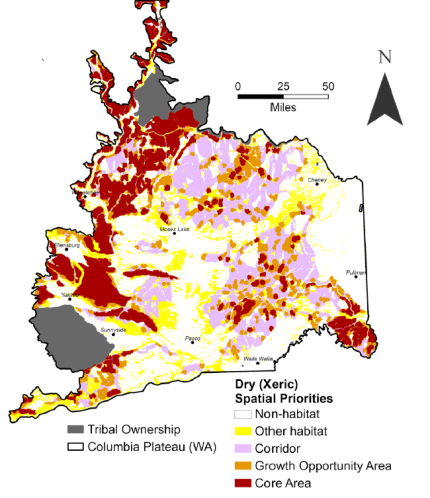
To guide where on the landscape WSRRI and its partners should invest proactively and implement specific actions, WSRRI partners mapped habitat quality and connectivity across the landscape, resulting in the following categories.
- Core areas have the highest-quality habitat, and actions targeted here should include protection, threat prevention and abatement, and restoration where disturbances occur despite protection measures.
- Growth Opportunity Areas still have significant amounts of habitat, but it is more degraded than habitat in core areas, and strategic restoration here could increase habitat quality and result in more core area.
- Corridors are relatively free of wildlife movement barriers and connect core areas and growth opportunity areas across the landscape; further barrier development (e.g., road construction, habitat conversion) should be avoided in corridors.
- Other Habitat is more degraded than the other three categories but is still important to retain and, if resources allow, their condition should be improved over time.

Spatial priority maps were developed for three conservation targets:
- Dry (Xeric) ecosystem includes drier environments primarily made up of sagebrush and perennial grasslands. Core areas for this target represent the largest blocks of native grasslands and shrublands in the region, and contain abundant perennial grass and forb cover, comparatively low amounts of invasive annual grasses, low human footprint, and often at least some sagebrush cover.
- Wet (Mesic) ecosystem includes wetter environments primarily made up of wetlands, wet meadows, and riparian habitats. Core areas for this target represent the largest concentration of these habitats with the lowest human footprint.
- Greater Sage-grouse. The Greater Sage-grouse spatial priorities reflect the species’ unique life history and are based largely on empirical data used to model sage-grouse habitat quality and connectivity. Greater Sage-grouse core areas may not be occupied now, but they contain abundant Sage-grouse habitat and correspond to the recent range of species.
While these maps will influence the geographic application of many specific WSRRI strategic actions and investments over its 30-year planning period, ongoing mitigation of threats to all shrubsteppe habitats, wildlife, and human communities across the shrubsteppe landscape will continue to be necessary.
Accessing WSRRI’s spatial priority maps
WSRRI spatial priorities documentation, including full descriptions of data inputs and mapping methods, as well as a tutorial for navigating WSRRI’s map portal can be accessed online. After viewing the documentation, the public and partners can visualize WSRRI's spatial priorities at the map portal:
Visit WSRRI spatial priorities map portal
Contact WDFW Remote Sensing and GIS Analyst Vincent Jansen at 360-902-2478 or vincent.jansen@dfw.wa.gov to access WSRRI’s spatial priority data in other formats.
Training
View a webinar on how to use the spatial priority mapping tools.
Long-Term Shrubsteppe Strategy
The Washington State Restoration and Resiliency Initiative (WSRRI) steering committee and advisors worked to build a long-term strategy for shrubsteppe conservation addressing spatial priorities, a wildlife habitat restoration program that coordinates and shares resources and services at the landscape scale, wildland fire protection and response, and the interaction with other threats to the shrubsteppe landscape.
WSRRI's Strategy, set for a 30-year period, includes five key elements focused on community engagement, habitat protection, habitat restoration, species management, and fire management. It emphasizes a strategic conservation approach, encapsulated in the "Defend the Core, Grow the Core, Connect the Core" principle. The initiative leverages advanced remote sensing and TerrAdapt’s data models for effective landscape-scale mapping and monitoring, for identifying spatial priorities for habitat protection and conservation.
The long-term strategy effort kicked off in January 2022 with the involvement of diverse stakeholders and facilitated by a neutral third party. The final Washington Shrubsteppe Restoration and Resiliency Initiative Long-Term Strategy (2024-2054) was published on March 1, 2024.

Contact
General inquiries: WSRRI@dfw.wa.gov
Hannah Anderson, Wildlife Diversity Division Manager
360-515-6885, hannah.anderson@dfw.wa.gov
Kurt Merg, WDFW WSRRI Shrubsteppe Restoration Coordinator
509-288-7067, kurt.merg@dfw.wa.gov